


")


")


")
")
Central Ukraine
Cherkassy Region
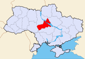
 Cherkassy region was established in 1954. Its area is 20,900 square km that makes 3.5% of total territory of Ukraine, its population makes about 1.5 mln or 2.9% of total population of Ukraine. The region is located in the centre of Ukraine in the forest-steppe zone of the country and has an
advantageous geographical position. Its territory is crossed by major highways, railways and the biggest river in Ukraine – the Dnieper (Dnipro) with its numerous tributaries.
Climate is temperate continental, mild winter with often thaws, warm summer with often droughts. Due to favourable climatic conditions the area is rich in picturesque forests and various fauna. Cherkassy land can boast for its beautiful landscapes and it is worth to visit the Sophievsky Park in Uman and National Park in Kanev. Cherkassy region possesses a wide range of minerals (over 110 deposits). In the left-bank part of the region there are large supplies of mineral-medical waters.Quite a number of sanatoriums and health protecting centres are located in this region.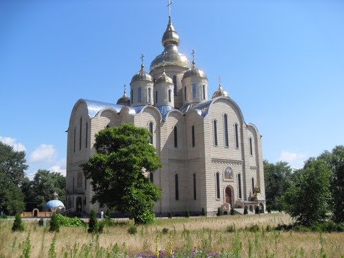
By the structure of economy the region is industrially-agrarian. The most productive structures are the enterprises of chemical, food, cellulose-paper and printing industry, enterprises of machine-building and processing of agricultural production. There are the most important branches in the food industry such as sugar (in the first decades of the XIX c. this area became centre of sugar-refining), meat processing, flour-grinding, liqueur and vodka production, canning. The agriculture is well-developed in Cherkassy region. As far as the soil fertility is concerned, the region occupies the first place in Ukraine. All categories of farms grow cereals and grain, legumes, sugar beet, sunflower, potato, maize and others. The stock-raising industry is intensively developed.
History of this region is very rich – the earliest traces of human settlement date from the VII-III cc. BC. To-day's Cherkassy area coincides with the territory of old Slavic civilization that was spread along the river Ros that later became part of the Kievan-Rus State. In 1239-1240 this area was devastated by Tartar-Mongolian invasions. In the second half of the XIV c. this land was conquered by the Lithuanians and a little later by the Poles.
By the late XV c. its main town Cherkassy became a major stronghold against the Tartars repeatedly invading Ukraine. Its history and history of many nearby towns is closely connected with the Cossack-Tartar wars, Koliyvshchyna (peasant and Cossacks) uprising (1768) and other mostly bloody pages of the Ukrainian history.
If you are specifically interested in the history of Cossacks and the endless wars they waged, the Hetman State, the Gaidamaks Movement, it is worth to take an outside trip to Chigirin and to Subotov. These trips will give you the feeling of those times «when blood was cheaper than wine, real men drank wine instead of water and used to sleep with their swords by the bed» (Sinkevich). In 1793, after the Hetmanate (a period of Ukrainian history when the country was headed by Hetman) was completely abolished (1764), the area became part of Russian empire. Up to the beginning of the XIX c. here was a constant fight between different cultures for this land.
One of the most severe battles during the Great Patriotic War took place in 1943 near Korsun-Shevchenkovsky. Cherkassy land gave life and accepted in its cuddles prophet of UkraineTaras Shevchenko. The state mind and military talent of Hetman Bogdan Khmelnitsky has been raised in Cherkassy land. Small town of Kamenka is associated with the history ofDecembrists’ movement and the names of Pushkin and Chaikovsky. And these are only a few names of famous people who loved this land. Chassidim from all over the world know a small town Uman where their spiritual leader Rebe Nachman from Bratslav was buried.
To learn more about sights, excursions and tours in this region click here
Poltava Region

 It is situated on the left bank of the Dnipro River in the Dnipro Lowland zone. The principal rivers in the region are the Vorskla, Psel (Pslo), and Sula. The climate is moderate-continental. There, are many mineral springs in the region; the largest of them are located in Myrgorod and Hoholeve. Area: 28,800 sq. km. Population: 1,771,000.
 Poltava land is one of the richest sources of Ukrainian spirit, the land of baroque architecture and pure nature. This is the land where famous Ukrainian philosopher, poet and enlightener Gregory Skoworoda started his traveling throughout the world.
Built in 1100 as a fortress, Poltava is one of the most picturesque spots in the country. Located on undulating hills crowned with good-domed churches, this traditionally hospitable city is a nice place to visit - especially on summer, when it is flooded in greenery. Many historical events that affected the course of national and world history are associated with this regional centre. Full day coach tour features visits to Museum of the History of the Battle of Poltava and the Poltave Battlefield Preserve.
Poltava is immortalized in Pushkin's poem of the same name, which describes the battle between invading army of Carl XII of Sweden, his Cossack allies led by Hetman Ivan Mazepa and the Russian army commanded by Peter the Great in 1709. The scene of the battle with it's surviving fortifications and many monuments to the fallen soldiers, looks like an open-air museum with atmosphere of it's own.
The village of Dykanka is a world famous place, which is known due to poems written by Mykolay Gogol "Evenings in the khutor near Dykanka" and by Pushkin "Poltava". Till today the residens take care of the native traditions and customs described by Gogol. Here one can visit such historical and natural monuments as Dykanka landscape park, Trinity Church, Saint Mykolay Church, Lilac Avenue, Pushkin's oaks. Also the one of the most visiting places in Poltava region is
Mirgorod spa resort
The curative properties of Mirgorod's mineral water have been known since the beginning of the 20th century. Mineral water from Mirgorod is as pure and tasty as mineral water from Baden-Baden, Aachen and Yessentuky, which made these resorts world-famous. Mirgorodskaya is a natural mineral water, transparent and slightly salty. Because of its unique curative properties, Mirgorodskaya mineral water is recommended for treating chronic gastritis, colitis, and other digestion disorders.
Mirgorod spa has a picturesque location at the bend of the River Khorol. Nature itself created ideal conditions for recreation in Mirgorod. It has a mild climate and a clean river. The environs boast a coniferous forest and a beautiful birch grove.
To learn more about sights, excursions and tours in this region click here
Kirovohrad Region

 Kirovograd region was established in 1939. Its area is 24,600 square km that makes 4.1% of total territory of Ukraine, its population makes about 1.1 mln or 2.3% of total population of Ukraine. It is situated in the Geographical centre of Ukraine, in the Dnieper upland steppe and forest-steppe zone between the Dnieper and the South Buh rivers. Numerous small rivers, ravines and gorges covered with woods in combination with vast fields give this land its own picturesque charm. Climate is temperate continental, mild winter with often thaws, warm summer with often droughts. This location greatly influenced the dynamic economic and social development of the region.
The steppe Kirovograd region has very fertile soils with the highest content of humus (4.5%). It is the large manufacturer of agricultural production and food stuffs. Here people grow wheat, corn, sunflower, sugar beats, rape and soy. The basis of the regional stock-raising is breeding of cattle, pigs, sheep and poultry. The food industry is represented by 11 sugar refineries, 5 distillers, dairy and meat factories, butter and sunflower oil production plants. There are not so many industrial centres in the region in spite of some big ones in the city of Kirovograd. And agricultural machine-building industry is of top importance. Different types of sowing machines such as grain, maize, vegetable, cultivators and stack racks, loaders and its spare parts, grain reaping-machines, combine harvesters are produced in the region. Heavy industry is based on the local mineral resources. These lands are rich in brown coal, ferruginous quartzites, uranium, nickel, graphite. Gold deposits have been also discovered in Kirovograd region, but the gold extraction is still on the very early preparatory stage.

These lands were first settled in the Palaeolithic Age. Some Tripilian culture and approximately 20 settlements of Chornolis culture (X-VII cc B.C.) have been discovered here. In the VII c. B.C. the region was settled by the nomadic Scythian tribes. More than 50 settlements containing early-Slavic monuments of Cherniahov culture have been excavated here. In the IX c. the Northern part of the region was part of the Kievan Rus state. But its biggest Southern part was not inhabited and was called “The Wild Field” and was of a kind of neutral land that was difficult to be controlled. In the mid-XIII c. its Northern territories came under the Lithuanian rule and were occupied by Poland after the union of Lublin in 1569. But even for these two superpower states of that time it was very difficult to become firmly established in these lands. In the second half of the XVI c. part of region’s territory was conquered by the Ukrainian Cossacks who defended the local population from the attacks of the Crimean Tartars. During the XVII c. peasant-Cossacks gaidamaks detachments fought in this area. In the mid-XVIII first settlements of a town type appeared here.
After the Russian-Turkish War of 1735-1739 it became part of Russia. Russia was interested in turning this area into a stronghold against the Turks and the Crimean Tartars. Numerous small military forts were constructed here and new people flooded this area. In 1764 the Elizavetinsky province of theNovorossiysk gubernia was created. At the beginning of the XIX c the territory of to-day’s Kirovograd region was included in the Podolia and Kiev gubernias.Kirovograd region has very rich history. But its specific location and its numerous small former fort posts that have gradually lost their importance explain the fact why this region can’t boast for the well known sites and typical tourist attractions. But on visiting its main city Kirovograd you will find some interesting architectural constructions and monuments of the last half of the XIX-beginning of the XX cc. characteristic for the provincial towns of Russia of that time.
Dnepropetrovsk Region

 The region was established in 1932. To-day its area is 31,900 square km or 5.3% of the total territory of Ukraine. The population of Dnepropetrovsk region estimates 3.5 mln (3,532,000) that constitutes 7.4 % of overall country population. The urban population makes 84%, and rural – 16%. By its national composition the region is multinational: 70% are Ukrainians, 20% are Russians, Byelorussians, Jews, Armenians and many other nationalities live here.
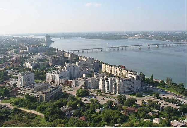
Dnepropetrovsk region is located in the steppe belt, in the middle and lower basin of the Dnieper river, which bisects the region from the North to the South for 270 km. The territory is a rolling flatland crossed by rivers and ravines. The left bank of the river is low and the right bank is rather hilly. The main river is the Dnieper and the rest smaller rivers are its tributaries. In the South of the region starts the Dnieper-Donbas man-made canal that brings water to the areas suffering from the droughts. Climate is temperate continental, winter is mild and summer is hot and dry with strong winds and draughts.
Most minerals of Ukraine are extracted here: manganese, iron ore, black and brown coal, oil, gas. The regional future is in development of non-ferrous, gold mining and gold processing industries. The potential resources of gold, molybdenum, tungsten in a few districts of Dnepropetrovsk region testify convincingly that after full completion of geological survey works the region will have a few large deposits of gold as well as medium deposits of molybdenum and tungsten. It also has one of the world biggest reserves of titanium and zirconium as well as powerful deposits of uranium and nickel ores.
 The region has powerful production potential. Its share in the gross domestic product makes up 17%. The regional enterprises provide up to 90% of iron-stone of the national production (Krivoy Rog deposits), 100% of manganese ore (the richest in the world manganese reserves are located in Nikopol district), 70% of rolled metal, 36% of cast-iron, 33.6% of steel, 75% of steel pipes, 13% of finished coal, 15% of mineral fertilizers and 24% of tires. The present economic potential of Dnepropetrovsk Region is more than 700 plants and factories, shafts, mines, mining and concentrating works, power stations, which cover about 20 main types of economic activity. The most developed industries are mining-metallurgical and machine-building complexes, chemical, processing and food industries. The region is a pioneer in the production of new synthetic materials and especially in the air and air-space technology. The space apparatus products of “Uzhmash” plant, which gave birth to the first Soviet rockets, have no analogy in the world. Over 40 leading enterprises of the region got the quality system international certificates
Dnepropetrovsk region plays leading role in the field of foreign economic activity of the country. The products of regional enterprises are known in the world markets and imported by over 100 countries of the world. For the last few years the investments from 60 countries of the world were attracted in the regional economy; over 460 enterprises with foreign investments are successfully functioning in all industries of economy. The region confidently keeps positions of one of the leading exporters of Ukraine, including export of hi-tech products.
The region is an important agricultural producer. 78.7% of the region’s territory is occupied by the farming land. The leading directions of agroindustrial complex are follows: growing of cereals, vegetable and technical crops, especially sugar-beats, sunflower; meat and dairy stock-raising and poultry farming are also developed.
By scientific and technical potential Dnepropetrovsk Region confidently occupies one of the first places in Ukraine.
We gave you some ideas about the present life of Dnepropetrovsk region, but what about its history? The first known settlements date from the early Palaeolithic era 100 thousand years ago. Archaeologists have discovered settlements and burial mounds of the Copper-Bronze Age. Remains of the Scythian, Sarmatian and Cherniahov cultures have been excavated. May be one of the most interesting and enigmatic was the time of the Scythians (VII-III cc. B.C.) that formed the first state on the territory of the present Ukraine. It was here, not far from the town of Nikopol, the burial tumuli of Scythian Tsars were found with beautiful gold decorations that now are exposed in many museums and known throughout the world.
The first Slavic settlements appeared here in the VI-VII cc. and they belonged to historical “Ants” – proslavic tribes, described by Byzantine authors. In the Kievan-Rus period (IX-XIII cc.) here along the Orel river was a border that conventionally separated Rus from the nomads’ lands and the Polovtsy steppe. The peculiarity of this period was in the fact that this territory was controlled by the Slavic principalities and often used for temporarily military camps during the raids to Crimea end Turkey, but there were no constant outposts or fortresses. In the mid-XIII c. these lands were controlled by the Golden Horde. Two big military forces, the Great Lithuanian Principality and the Crimean Khanate, competed for these lands known as a part of the “Wild Field” in the XIV-XV cc., but nobody won.
A new period started at the 1550-ies when the runaway peasants and Cossacks started to organize on the free lands behind the Dnieper rapids their military camps and outposts. The first Northern rapid (Kodaksky) was on the site of present Dnepropetrovsk. Such settlement got the name of “Sech” (abattis) and the Cossacks called themselves “Zaporozhian Cossacks” that meant “those who lived behind the rapids”. The Cossacks protected the lands from the Tartar raids and waged campaigns on land and on sea against Turkey and Crimea. The Cossacks also played a significant part in the national-liberation war against Poland and supported the union with Russia in 1654. The Cossacks were always the defenders of freedom and independence, their rebellious and difficult to be controlled activity contradicted with the policy of Russian tsars. In 1709 after the Poltava battle, when part of the Cossacks betrayed Russian Tsar Peter the Great and supported Swedish king Charles XII, the Tsar ordered the liquidation of the Zaporozhian Sech. In 1743 the Cossacks again were allowed to have their own territory and military detachments, but never again it reached its former power and glory. In 1775 the Tsarist army, by the order of Catherine II, occupied and destroyed the Sech and its lands were annexed to the Azov and Novorossiysk guberias. More about this very interesting period one can learn on visiting the Museums of Dnepropetrovsk.
The period of intensive settlement of these lands began in the second half of the XVIII c. after the end of the Russian- Turkish war of 1768-1774. The Government generously presented these free lands of the former Wild Field to retired officers and soldiers, foreigners were welcomed too. In 1779 the Greeks, Georgians and Armenians came here. In 1782 the Kalmyks were brought here from the Ural steppes. In 1786 the first big group of Germans was welcomed. The Germans were always under special protection of the Empress and got the best lands. After the second partition of Poland the Jews came here too. The new settlers were released from any taxes for 10 years. The exploitation of the iron ore deposits of Krivoy Rog in 1881 and the construction of the rail road that connected the region with Donbas in 1882 urged the intensive industrial development of this area.
During the years of the Revolution of 1917 and the Civil War up to 1919 the region witnessed endless revolts, clashes and bloody battles. In 1930-ies a real construction and industrial boom started. In 1932 five districts were united in one big Dnepropetrovsk region. It was the year when an administrative reform was organized in Ukraine and the whole country got the new administrative division. During the years of Great Patriotic War Dnepropetrovsk region suffered greatly. In 1942 the retreating Red Army undermined and destroyed all major enterprises. The Germans tried hard but failed to launch them again. It was very important for the whole USSR to rebuild the industrial potential of the region in the post-war years. And it was done by 1950-ies.
Due to the fact that Dnepropetrovsk region was populated only within the last three centuries and its life was conditioned by the development of heavy industry there are not so many very old historical monuments. And even its glorious Cossack history was destroyed in the Soviet era. But nevertheless, a tourist can find many interesting facts not only about the region but about the whole Ukraine during his stay in its main city Dnepropetrovsk. Those interested in the industrial potential of Ukraine will find it useful to visit the second biggest city of the region Krivoy Rog and the manganese capital of the region -Nikopol. To get acquainted with authentic Ukrainian folk art one must go to Petrikovka. One of the most beautiful wooded churches in Ukraine can be found in Novomoskovsk.
We must admit that for tourists it is quite unknown region. For many years during the Soviet era practically all area of Dnepropetrovsk region was closed for foreigners because many its industrial enterprises, scientific and research institutions were military orientated and that is why were of top secrecy. This phenomenon to some extend explains the fact why to-day this region has the largest in Ukraine industrial and scientific potential. Dnepropetrovsk Region to-day is one of the most perspective, industrial and cultural well-developed centres of Ukraine. Welcome!